ASIA GIS 2001–Collaboration through GIS in the Internet EraⅠ(2001.7)
June 20-22, 2001
Co-authors:Hui-Chi Rosa Huang**Chi Chien Lian***Cheng Yi Ping****
GIS and the Construction of Digital Social Maps—“The Shihlin District Humanities and Social Sciences Laboratory”in Taipei City
Key Words: Interdisciplinary Integration, Digital Social Maps, Geographic Information Systems (GIS), Location Analysis, Personal Digital Assistant (PDA), Global Positioning Systems (GPS).
Of special interest on the interdisciplinary integration of the Humanities and Social Sciences, this paper focuses on the methodology and the design of achieving the goal. Two case studies, the project of ‘Social Survey of the Kuting District in Taipei City (1964)’ and the project of the ‘Shihlin District Humanities and Social Sciences Laboratory in Taipei City(2000),’mark the advantages of applying Geographic Information Systems (GIS) into the research of Humanities and Social Sciences. In contrast with the Kuting District’s case, the Shihlin’s Laboratory project reveals the creativity of ‘digital social maps’ and the weakness of traditional hand-made ‘social maps’. Methodologically, GIS serves as a common operating panel for all design in the Shihlin project.
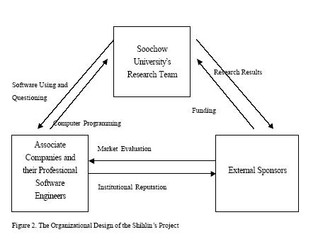
To construct digital social maps, the Shihlin project executes two kinds of designs: (1) the organizational design, and (2) the practical design. In regard to the project’s organizational design, it includes the interaction of the following three elements, associate companies and their professional software engineers, the leadership and members of Soochow University’s research team, and external sponsors. The three elements are not separable. Well designed GIS or PDA software will fail if they lose the support of the research team and the external sponsors. If the software systems fail to provide needed answers to the questions at hand, they are likely to lose their institutional support.
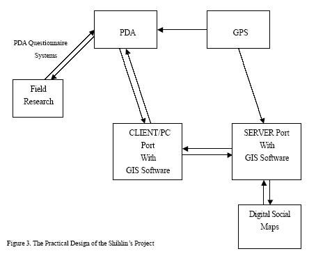
The project’s practical design refers to the creative interdependence of Geographic Information Systems (GIS), Personal Digital Assistant (PDA), and Global Positioning System (PDA). In replace of the traditional human coding of social survey, the project creates a digitalized method of field research. The researcher may use PDA and its installed questionnaire systems to collect the spatial and attribute data. To correct the error of traditional ‘social maps,’the researcher could incorporate PDA and GPS into GIS for creating digital social maps.
* Head Administrator of the “Shihlin’s Humanist-Societal Laboratory” project, Assistant Professor, Department of Sociology, Soochow University, Sh ihlin, Taipei 111, Taiwan, R.O.C. TEL: (0) 02-2881-9471~6311. FAX: 02-8861-5877. EMAIL:cstone@mail.scu.edu.tw
** Research Assistant of the “Shihlin’s Humanist-Societal Laboratory” project. Ph.D. Candidate, Institute of Building and Planning, National Taiwan University.
EMAIL:d5544005@ ms.cc.ntu.edu.tw
*** Research Assistant of the “Shihlin’s Humanist-Societal Laboratory” project. MA Student, Institute of Social Informatics, YuanZe University. EMAIL:s897902@mail.yzu.edu.tw
**** Research Assistant of the “Shihlin’s Humanist-Societal Laboratory” project. MA Student, Department of Sociology, Soochow University, Shihlin, Taipei 111, Taiwan, R.O.C. EMAIL:u9315002@mail.scu.edu.tw
Since the last century, deep in the heart of the Great West, Chicago has long been seen as the unique American city. The city prospered by providing the locality to open the frontier for the Northern industry and the Southern farming and then transforming the city into a metropolis. Chicago was best known as the capital of no-nonsense business, and especially for the large-scale manufacturing of capital goods*. Its workforce was swollen by successive waves of immigrants from various parts of Europe, Africa, Latin America, and Asia. Along with the industrialization and the increasing population, Chicago faced critical problems of social security, race conflict, and resource distribution. The Chicago school, the precursor of‘human ecology,’established research laboratory to study the rich research topics and projects in Chicago. It was the first‘social laboratory’in the Humanities and Social Sciences. The idea influenced scholars’research in Taiwan. In 1965, Professor Kwan-hai Lung in National Taiwan University issued a‘Social Survey of the Kuting District of Taipei’project and drew several‘social maps’(Shih, 2000). In 1974, Professor Mau-tzung Yang in Soochow University established a‘university laboratory’for community research and service. For elaborating the idea of university laboratory, the current project,‘Shihlin District Humanities and Social Sciences Laboratory in Taipei City,’explores the humanist and social topics in the local area and creates‘digital social maps’.
To examine Shihlin District as a regional construct, the project proposes practical and theoretical elaborations to go beyond the region as merely a backdrop. First, Shihlin District is a unique case of GIS application. Located in
————————————————
* David Moberg: Chicago, To Be or Not to be a Global City. World Policy Journal, p. 71, Spring, 1997.
the Taipei basin, coexisted of mountain and river, terrace and plain, and the elements of city and country that effectively shaped Shihlin District to be one of the most beautiful areas in Taipei city. In the project, we divided the Shihlin District into seven sub-district: (1) Yang-ming Mountain sub-district, (2) Tang-mu sub-district, (3) Lang-ya sub-district, (4) Zu-shang Rock sub-district, (5) Street sub-district, (6) Ho-gang sub-district, and (7) Sher-Ji Island sub-district. Second, Shihlin District provides an excellent case for GIS urban/regional study not only because the diversity of its non-human resources, but also the diversity of its human resources. For example, Tang-mu sub-district is famous for its multi-national ethnicity and landscape. We can still see Japanese, Englishman, Korean, and other country’s people walk in the area all time. Yang-ming Mountain sub-district used to be the military base of American army. Many American-style radio stations and housings still located at the area. The multi-national nature of Shihlin District enable the perspective of interaction of globalization, localization, and the particular role of the state as a central institutional element in the process of social change and urbanization to be analyzed, and permits a more ‘organic’ approach to be developed. The Shihlin project contains eight sub-projects.
Investigators include professors from department of Sociology, Social Work, History, Philosophy, Music, Politics, Chinese Literature, and Education. The sub-projects * are (1) the construction and management of GIS in the laboratory, (2) the development of Shihlin’s oral history, convention, historic spot, and culture, (3) the collection of Shihlin’s music resource, (4) the development of Shihlin’s religious organization, (5) the development of Shihlin’s family and educational
————————————————
* Professor C.S. Stone Shih is the investigator of the first sub-project and the co-investigator of the seventh sub-projects.
institution, (6) the distribution of Shihlin’s Medicare and social welfare, (7) the development of community power and industrial ecology, and (8) the pattern of Shihlin’s local political factions, political-commercial relationships, and vote behaviors.
As the external sponsor, National Science Council has funded the Shihlin project for three years. In the first year, the project focuses on data collection and the construction of database. Furthermore, we will create a base map and several thematic maps by GIS. In the second year, the project will concentrate on the interaction of all sub-projects through the application of Nuro-network system. In the third year, the project will establish its own web site and provide Shihlin’s attribute data and thematic maps for Taipei’s citizens via Web GIS system (Shih, 2001).
As the external sponsor, National Science Council has funded the Shihlin project for three years. In the first year, the project focuses on data collection and the construction of database. Furthermore, we will create a base map and several thematic maps by GIS. In the second year, the project will concentrate on the interaction of all sub-projects through the application of Nuro-network system. In the third year, the project will establish its own web site and provide Shihlin’s attribute data and thematic maps for Taipei’s citizens via Web GIS system (Shih, 2001).
2.SOCIAL MAPS V.S. DIGITAL SOCIAL MAPS
2.1Social Maps: The Precursor
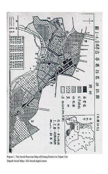
In 1965, Professor Kwan-hai Lung in National Taiwan University issued an outstanding ‘Social Survey of the Kuting District of Taipei’ project and drew fifteen sheets of ‘social maps’. The maps included the description of ecological structure, population, family, the distribution of industry and commerce, the employment of conditions of the inhabitants, education and cultural organizations, religious organizations, civic groups and rganizations, social welfare organizations, recreational organizations, medical organizations, and housing conditions in Taipei’s Kuting District. As Figure 1 has shown, the social function map intended to divide Kuting District into commercial area, residential area, public facilities, farmland, and other area (e.g., mountain, empty place, and river) in terms of their community functions. The legend in the map included city line, district line, neighborhood line, railway, street, bridge, number of sub-divisions, sub-division line, number of neighborhoods, and so on. All these GIS’s spatial elements, point, line, and polygon, coexisted in a map. The complexity of topology in the hand-made map made readers feel tired and confused visually. For example, it seems that the commercial area located along the main streets (without names) of the Kuting District. The residential area, and public facilities were right next to the commercial area. But we were not sure the exact locations of those social function areas. The expression of legend was also a big problem. We could see there were five areas/polygons, commercial area, public facilities, residential area, farmland, and others, in the legend. However, the pre-GIS legend created difficulty for viewing the map. For example, the legend of farmland contained ‘point’ spatial element in the ‘polygon.’ The legend of public facilities contained ‘line’ spatial element in the ‘polygon.’ The way of expression confused readers a lot for viewing the real line elements, such as street, railway, neighborhood, city, and area. It also disturbed our visual clearness of point element, such as the number of neighborhood.
Location analysis is one of the research methods of human ecology. Mainly, the method focuses on the spatial distribution patterns or organizational systems of human and the facilities*. Thus, the drawing of social maps is the realization of location analysis. From the GIS points of view, however, Figure 1 was a map without concepts of spatial analysis. Hardly could we tell the exact locations of those social function areas in Kuting District. Besides, we could not know the connection of the attribute data and the spatial data from the map itself. The only way to understand the meaning of the social function map was back to the text of the social survey. Thus, the 1965 social map was not the subject of the research, but a supplement of literal description.
————————————————
* Kwan-hai Lung: A Social Survey of the Kuting District of Taipei City. P.24, 1965.
2.1Social Maps: The Precursor
In 1965, Professor Kwan-hai Lung in National Taiwan University issued an outstanding ‘Social Survey of the Kuting District of Taipei’ project and drew fifteen sheets of ‘social maps’. The maps included the description of ecological structure, population, family, the distribution of industry and commerce, the employment of conditions of the inhabitants, education and cultural organizations, religious organizations, civic groups and rganizations, social welfare organizations, recreational organizations, medical organizations, and housing conditions in Taipei’s Kuting District. As Figure 1 has shown, the social function map intended to divide Kuting District into commercial area, residential area, public facilities, farmland, and other area (e.g., mountain, empty place, and river) in terms of their community functions. The legend in the map included city line, district line, neighborhood line, railway, street, bridge, number of sub-divisions, sub-division line, number of neighborhoods, and so on. All these GIS’s spatial elements, point, line, and polygon, coexisted in a map. The complexity of topology in the hand-made map made readers feel tired and confused visually. For example, it seems that the commercial area located along the main streets (without names) of the Kuting District. The residential area, and public facilities were right next to the commercial area. But we were not sure the exact locations of those social function areas. The expression of legend was also a big problem. We could see there were five areas/polygons, commercial area, public facilities, residential area, farmland, and others, in the legend. However, the pre-GIS legend created difficulty for viewing the map. For example, the legend of farmland contained ‘point’ spatial element in the ‘polygon.’ The legend of public facilities contained ‘line’ spatial element in the ‘polygon.’ The way of expression confused readers a lot for viewing the real line elements, such as street, railway, neighborhood, city, and area. It also disturbed our visual clearness of point element, such as the number of neighborhood.
Location analysis is one of the research methods of human ecology. Mainly, the method focuses on the spatial distribution patterns or organizational systems of human and the facilities*. Thus, the drawing of social maps is the realization of location analysis. From the GIS points of view, however, Figure 1 was a map without concepts of spatial analysis. Hardly could we tell the exact locations of those social function areas in Kuting District. Besides, we could not know the connection of the attribute data and the spatial data from the map itself. The only way to understand the meaning of the social function map was back to the text of the social survey. Thus, the 1965 social map was not the subject of the research, but a supplement of literal description.
————————————————
* Kwan-hai Lung: A Social Survey of the Kuting District of Taipei City. P.24, 1965.
Due to the weakness of traditional social maps, the Shihlin project uses GIS software as a common operating panel for all design to ‘interpret the space, and to explore the typology’ of different variables of social realities. In a word, we apply GIS and its software to create ‘digital social maps.’ Researchers may test their hypotheses in the process of operating GIS software. In 2000, the research team of Soochow University issues a project ‘Humanities and Social Sciences Laboratory :The Research on Human-Societal Changes of Shihlin District in Taipei City’ to explore the idea of digital social maps.
To correct the error of Professor Kwan-hai Lung’s‘ social maps,’ the purpose of the new project is to develop a data structure of digital social maps and to turn space itself into a real variable in which to carry both attribute and spatial data. In advance, the new project intends to analyze the patterns of spatial aggregation and dispersion of those variables of social realities and develop comparative study of regional typology in the future. We would expect a scientific integration happened if we could solve the problems of designation of the second generation of GIS, the analysis of historical data in GIS, and the high cost of buying GIS software.
To correct the error of Professor Kwan-hai Lung’s‘ social maps,’ the purpose of the new project is to develop a data structure of digital social maps and to turn space itself into a real variable in which to carry both attribute and spatial data. In advance, the new project intends to analyze the patterns of spatial aggregation and dispersion of those variables of social realities and develop comparative study of regional typology in the future. We would expect a scientific integration happened if we could solve the problems of designation of the second generation of GIS, the analysis of historical data in GIS, and the high cost of buying GIS software.
2.2Data Mining and The Construction of Digital Social Maps
In the current project, the purpose of data mining is to construct Taiwan’s first ‘Database of the Digital Social Maps in Shihlin District of Taipei City.’ Thus, we provide two kinds of design: the organizational design, and the practical design of the project.
In the current project, the purpose of data mining is to construct Taiwan’s first ‘Database of the Digital Social Maps in Shihlin District of Taipei City.’ Thus, we provide two kinds of design: the organizational design, and the practical design of the project.
2.3The Organizational Design of the Shihlin’s Project
As Figure 2 has shown, in regard to the project’s organizational design, it includes the interaction of the following three elements, associate companies and their professional software engineers, the leadership and members of Soochow University’s research team, and external sponsors. GIS is essentially a high-tech science.
We need associate companies and their professional software engineers to take care of the technological problems of the users. In this regard, researchers in Humanist and Social Science may not stay in a tower of ivory anymore. Scholars in academy should incorporate into the commercial and the industrial. Secondly, the project’s organizational design refers to a system design, a leadership. There must be a man, or a group of men, may remain vision and make a long-term plain for the individual users, team workers, and the computers. In the project, Professor Tsai Ming-Je continues the idea of university laboratory and I provide the vision of GIS professional knowledge. Under this leadership, the Shihlin project stays in good shape. Furthermore, the three elements, associate companies and their professional software engineers, the leadership and members of Soochow University’s research team, and external sponsors are not separable. Well designed GIS or PDA software will fail if they lose the support of the research team and the external sponsors. If the software systems fail to provide needed answers to the questions at hand, they are likely to lose their institutional support. On the one hand, the huge funds for operation in the project are mainly from the National Science Council of R.O.C. government. Soochow University’s research team is responsible for the external sponsor. We are obligated to report our research results to the National Science Council. On the other hand, the associate companies and their professional engineers of GIS and PDA need to take care of computer programming and answer the questions of Soochow University’s researchers. The associate companies, facing serious market competition, are sometimes doing business directly to external sponsors. They could be other research or governmental units. In this regard, the institutional reputation of the external sponsors is the main consideration of the associate companies. The market evaluation of the associate companies is the bottom line for external sponsors to choice the companies in the market.
2.4The Practical Design of the Shihlin’s Project
As Figure 3 has shown, the project’s practical design refers to the creative interdependence of Geographic Information Systems (GIS), Personal Digital Assistant (PDA), and Global Positioning System (PDA). In replace of the traditional human coding of social survey, the project creates a digitalized method of field research. The researcher may use PDA and its installed questionnaire designing systems to collect the spatial and attribute data.
Table 1 highlights the three-steps process of building a digitalized questionnaire. First of all, we installed the questionnaire designing system into the researcher’s PC site. Researchers just follow the system and add new questions and items by themselves. For example, we ask the following questions: How long do you live in Shihlin district? What is your occupation? Do you cast every voting? Have you been served a job about voting’s matter before? Have you ever been running for a public job?
Secondly, after designing these questions in the questionnaire system, we save the designed questionnaire file and then transfer the file into to the PDA Site. At this time, researchers can take their own PDAs to the fields for data collection. PDA can record any form of interview’s data (including word files, voice files, and video files) and transfer the data back into PC site’s database (in the form of excel files). Thirdly, we transfer the data in PDA Site back into the PC Site. We can transfer the data into SPSS, clean the data and perform statistic analysis , and transfer the data into WinGIS and become useful attribute information.
To correct the error of traditional ‘social maps,’ the researcher could incorporate PDA and GPS into GIS for creating digital social maps. At this stage, this digitalized method of field research also allows researchers to collect special data, such as word files, voice files, and video files. The location of these data does not have an address in the Shihlin’s base-map. The good thing of this method is it has already installed Global Positioning System in PDA and its questionnaire designing system.
Rather than coding the address of research object, in this regard, we may just key in the X, Y coordinates to PDA and then follows the steps to complete the process. After collecting data from different researchers, we may concentrate all data into the server port of the Shihlin project and create digital social maps easily from the GIS software. As Figure 3 has shown, with the help of GIS, PDA, and GPS, the back-and-forward process of data collecting could add, delete, remove, or update our digital social maps in any available time. Thus, we may create a better database.
2.5Data Mining and Digital Social Maps
After introducing the organizational and practical designs of the Shihlin project, we demonstrate a new data mining system for creating digital social maps. With the idea of Professor C. S. Stone Shih and engineers of Major Technologies, we create a ‘ Standardized Data Mining System Design of Shihlin Humanist-Social Laboratory.’ The system serves as a common operating panel for all digital social maps design in the Shihlin project. It includes two operating systems: (1) Base Map Input System; and (2) Domain Information/ Thematic Maps System. The Base Map Input System involves the construction of base map of the whole database and the Domain Information/ Thematic Maps System deals with the building of thematic maps for every sub-project in the Shihlin Laboratory. In a word, digital social maps include base maps and thematic maps. The combination of the two kinds of maps depends on the idea of researchers.
Researchers of sub-project 1 and associate companies have already created the base maps for all other researchers in the project. In other word, base maps are a ‘given’ data in the Base Map Input System. They are fundamental data for creating digital social maps. They include two kinds of data: spatial data and attribute data. As Table 2 has shown, spatial data are layers, such as Shihlin seven sub-district maps, Shihlin’s neighborhood names, Shihlin’ doorplate number maps, Shihlin’s street names, Shihlin ’s land marks, Jie Shan sub-district, She Zi sub-district, Lan Ya sub-district, Tian Mu sub-district, Zhi Shan sub-district, Hou Gang sub-district, and Shan Shang sub-district. Head administrator of the Shihlin project controls the spatial data in the Base Map Input System from the server port. Attribute data include Shihlin’s measure of area, names of villages, total population of villages, male population of villages, female population of villages, adult population of villages, young population of villages, address of doorplate number, X coordinate of doorplate number, Y coordinate of doorplate number, the district name of doorplate number, the village name of doorplate number, the city name of doorplate number, the road name of doorplate number, and the lane name of doorplate number. The base maps, spatial data and attribute data, could not be added, deleted, removed, or updated from anyone only if under the authorization of leaders in the organization.
Domain Information/ Thematic Maps System is a system for creating thematic maps. Researchers may create their own thematic maps by their own research interests. They can create all kinds of domain data. For example, researchers may be interest in Shihlin ’s oral history and create a layer in GIS software. The layer is defined as geographic data. The geographic data must be related to table forms of data.
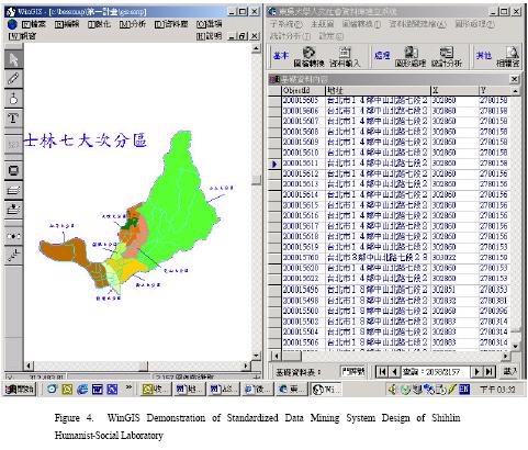
For example, the table of oral history is related to its spatial location by either doorplate number or X, Y coordinates of GPS. Both geographic data and related data are one-on-one relationships. As Figure 4 has shown, we can overlay domain data/thematic maps with base maps via the Standardized Data Mining System Design of Shihlin Humanist-Social Laboratory. The WinGIS demonstration shows the complete vision of the system. The left side of Figure 4 is the Base Map Input System, and the right side of the figure is the Domain Information/Thematic Maps System. Researchers can provide different options for creating all kinds of thematic maps. For example, Figure 4 to show all the attribute and spatial data of the Tang Mu sub-district. In this way, researchers complete the construction of digital social maps very easily.
After introducing the organizational and practical designs of the Shihlin project, we demonstrate a new data mining system for creating digital social maps. With the idea of Professor C. S. Stone Shih and engineers of Major Technologies, we create a ‘ Standardized Data Mining System Design of Shihlin Humanist-Social Laboratory.’ The system serves as a common operating panel for all digital social maps design in the Shihlin project. It includes two operating systems: (1) Base Map Input System; and (2) Domain Information/ Thematic Maps System. The Base Map Input System involves the construction of base map of the whole database and the Domain Information/ Thematic Maps System deals with the building of thematic maps for every sub-project in the Shihlin Laboratory. In a word, digital social maps include base maps and thematic maps. The combination of the two kinds of maps depends on the idea of researchers.
Researchers of sub-project 1 and associate companies have already created the base maps for all other researchers in the project. In other word, base maps are a ‘given’ data in the Base Map Input System. They are fundamental data for creating digital social maps. They include two kinds of data: spatial data and attribute data. As Table 2 has shown, spatial data are layers, such as Shihlin seven sub-district maps, Shihlin’s neighborhood names, Shihlin’ doorplate number maps, Shihlin’s street names, Shihlin ’s land marks, Jie Shan sub-district, She Zi sub-district, Lan Ya sub-district, Tian Mu sub-district, Zhi Shan sub-district, Hou Gang sub-district, and Shan Shang sub-district. Head administrator of the Shihlin project controls the spatial data in the Base Map Input System from the server port. Attribute data include Shihlin’s measure of area, names of villages, total population of villages, male population of villages, female population of villages, adult population of villages, young population of villages, address of doorplate number, X coordinate of doorplate number, Y coordinate of doorplate number, the district name of doorplate number, the village name of doorplate number, the city name of doorplate number, the road name of doorplate number, and the lane name of doorplate number. The base maps, spatial data and attribute data, could not be added, deleted, removed, or updated from anyone only if under the authorization of leaders in the organization.
Domain Information/ Thematic Maps System is a system for creating thematic maps. Researchers may create their own thematic maps by their own research interests. They can create all kinds of domain data. For example, researchers may be interest in Shihlin ’s oral history and create a layer in GIS software. The layer is defined as geographic data. The geographic data must be related to table forms of data.
For example, the table of oral history is related to its spatial location by either doorplate number or X, Y coordinates of GPS. Both geographic data and related data are one-on-one relationships. As Figure 4 has shown, we can overlay domain data/thematic maps with base maps via the Standardized Data Mining System Design of Shihlin Humanist-Social Laboratory. The WinGIS demonstration shows the complete vision of the system. The left side of Figure 4 is the Base Map Input System, and the right side of the figure is the Domain Information/Thematic Maps System. Researchers can provide different options for creating all kinds of thematic maps. For example, Figure 4 to show all the attribute and spatial data of the Tang Mu sub-district. In this way, researchers complete the construction of digital social maps very easily.
3.CONCLUSIONS
The purpose of this paper focuses on the method and process of creating digital social maps. Two case studies, the project of ‘Social Survey of the Kuting District in Taipei City (1964)’ and the project of the ‘Shihlin District Humanities and Social Sciences Laboratory in Taipei City (2000),’ mark the advantages of applying Geographic Information Systems (GIS) into the research of Humanities and Social Sciences. In contrast with the Kuting District’s case, the Shihlin’s Laboratory project reveals the creativity of ‘digital social maps’ and the weakness of traditional hand-made ‘social maps’. Methodologically, GIS serves as a common operating panel for all design in the Shihlin project.
In the current project, we successfully develop organizational and practical design systems for constructing Taiwan’s first ‘Database of the Digital Social Maps in Shihlin District of Taipei City.’ In replace of the traditional human coding of social survey, the project creates a digitalized method of field research. The researcher may use PDA and its installed questionnaire designing systems to collect the spatial and attribute data. In advance, we also design a WinGIS-based Standardized Data Mining System Design of Shihlin Humanist-Social Laboratory. The friendly system helps all researchers create their own thematic maps easily. In the future, the Shihlin project expects to create a large database and two-ways queries via the Web-GIS technology.
4.REFERENCES
Arnoff Stanford 1989 Geographic Information Systems: A Management Perspectives. WDL Publications, Ottwa, Canada.
Burrough P.A. 1987.: Principles of Geographic
Information Systems of Land Resources. Assessment. UK: Oxford University Press,
C. S. Stone Shih 2001: Geographic Information Systems in Sociology. Taipei: Rwu-Ling Publisher,.
C. S. Stone Shih 2000: The Integrative Basis of Social Sciences—Geographic Information Systems and the Structures of Digital Social Maps. Chinese Geographic Information Association, Conference Paper, Tainan: National Cheng-Ku Univeristy.
David Moberg 1997: Chicago, To Be or Not to be a Global City. World Policy Journal, p. 71, Spring,.
Demers, 1997 Michael N: Fundamentals of Geographic Information Systems. John Willey and Sons Press,.
Kwan-hai Lung 1965: A Social Survey of the Kuting District of Taipei City. P.24,.
Star J., J.E. Estes 1990: Geographic Information Systems: an Introduction. N.J.: Prentice Hall, Englewood Cliffs,.